
NSF COLDEX team wraps up the ‘24-’25 field season in Antarctica
Hello again from US National Science Foundation COLDEX. Since our last update, our two field teams have returned home from the 2024-2025 Antarctic field season and resumed their everyday lives, and the ice cores that they collected have begun making their slow journey to their forever home, the National Science Foundation Ice Core Facility in Colorado.
We caught up with Bridget Hall, science team member and Master’s student at the University of Minnesota, who collected various of her team member’s thoughts on the field season and shared them with us, alongside some final photos from Antarctica.
Here it is:
“The science at Site A is officially done and the team is home!
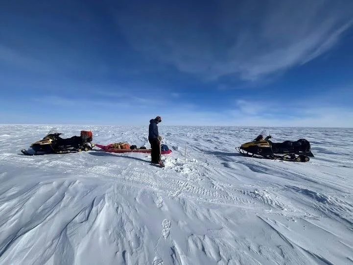
Over the final week, Knut Christianson and John Paden dragged the two radars over the last lines, all of the magnetotelluric systems and seismic nodes were collected, and the last of the pRES sites were visited. Each of these activities required many, many hours driving on skidoos. The furthest skidoo ride was a massive 75 kilometers, completed by Megan Kerr and JM Manos!

Knut and John preparing the radar for a long day of driving.
A couple of these systems haven’t been properly introduced yet, so here are some explanations for you:
Magnetotelluric/seismics - Megan Kerr, PhD student at the University of Texas at Austin:
“In addition to geophysical methods targeting the ice sheet itself, the I-186 team used magnetotelluric and seismic techniques to investigate the geological characteristics of the crust directly beneath the ice sheet, which can both impact and be affected by the behavior of the ice.
The magnetotelluric method (MT) is a passive geophysical technique which measures subsurface electrical and magnetic fields induced by natural variations in the earth’s magnetic field. The frequency and phase of the signals we measure tell us how the electrical resistivity of the crust varies with depth. These measurements can be used to infer the presence or absence of geological features such as groundwater, sedimentary materials, and fault zones.
Deploying an MT station requires burying multiple electrodes and magnetometers beneath the snow surface and setting up a receiver to record the data. Pre-amplifiers are connected to the electrodes to overcome the high contact impedance of firn. We used solar panels as well as batteries to power the stations, taking advantage of the 24-hour sunlight of Antarctic summers. Each station was deployed for 2-7 days before being moved to a new site.
MT Deployment. Image by John-Morgan Manos.
We also collected data using nodal seismometers, which measure ground movement caused by earthquake activity as well as non-seismic noise like wind and glacier movement. Combined with MT, this data will be used to investigate the geology beneath the ice sheet and help us understand the ice sheet’s behavior from the bottom-up.
Node deployment. Image by Megan Kerr.
Nodes downloading at South Pole. Image by Bridget Hall.
Forty-two seismic nodes were deployed throughout the field site, covering nearly 150 km total. The small sensors were buried beneath the snow surface, spaced 1.5-4 km apart, and left for the duration of the field season.”
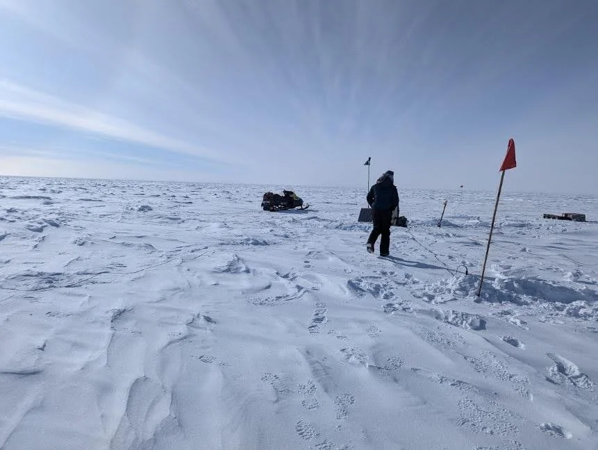
pRES - Ellen Mutter, PhD Student at Cornell University:
“The Autonomous phase-sensitive Radio Echo Sounder (ApRES) is a radar instrument that allows us to take measurements of reflection horizons in the ice sheet (englacial reflections) with mm-scale precision. We use these high precision measurements to investigate how the crystal structure of ice evolves with depth and to measure the vertical movement of the ice sheet.
To investigate the crystal structure, we collect measurements using different orientations of radar waves. To change the orientation, or polarization, of the radar wave, we rotate the orientations of the two radar antennas (see photo below).
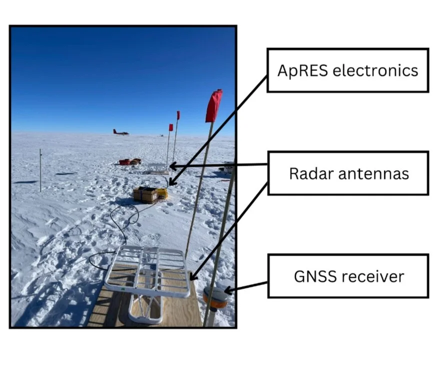
The ApRES setup has three main components: two white skeleton antennas, the radar electronics (housed in a yellow Pelican case), and a battery. We also use a GNSS receiver to record the precise position of the antennas. Image and figure by Ellen Mutter.
Because the crystal structure of ice contains asymmetries, the speed at which the radar wave travels through ice depends on the relative orientations of the radar wave (the polarization) and the ice crystal. We use different pairs of polarized radar waves to calculate how the speed of light changes with depth, and thus can characterize the crystal structure of the ice sheet.
To investigate the vertical movement of the ice, we use two ApRES measurements taken at the same location one year apart. We calculate the vertical velocity by picking strong englacial reflections (see plot below) and looking at how the distance between the englacial reflections and the bed reflection (see plot below) have changed between the two measurements.
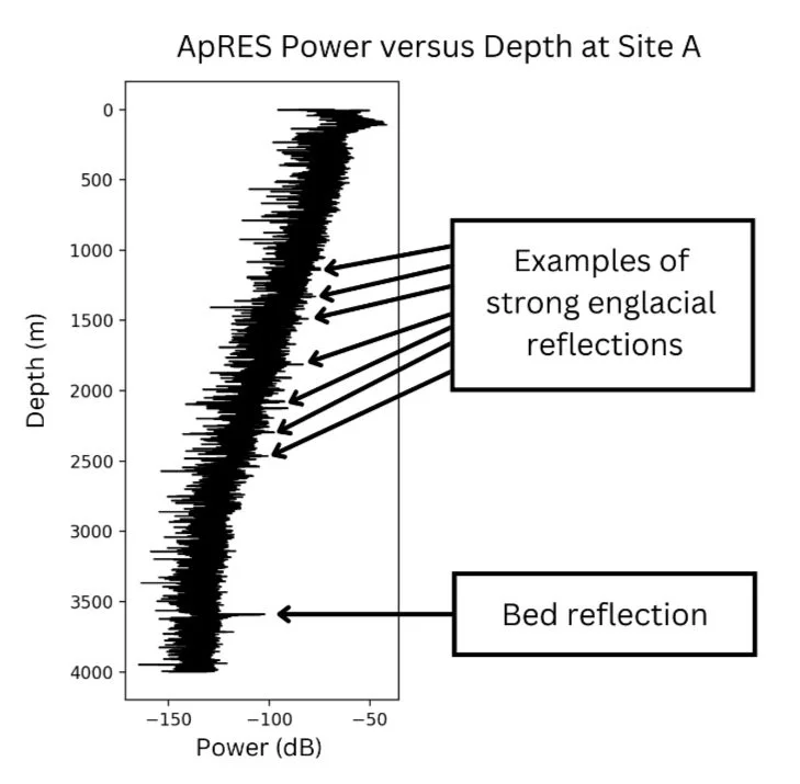
This plot shows the power of radar reflections recorded during an ApRES measurement. We see that as the radar reflections reach deeper into the ice sheet the power generally decreases. At mid-range depths there are spikes where the power jumps to higher values—these are our strong englacial reflections. The deepest spike in power marks the depth where ice meets rock at the bed of the ice sheet. Figure by Ellen Mutter.
Our measurement sites this year included a line of 5 ApRES sites located 50 to 1050 kilometers down flow from camp accessed via Twin Otter plane, 1 ApRES site located 30 km up flow from camp accessed via a 12-hour round trip skidoo journey, and a grid of 13 ApRES sites located within 5 km of camp accessed via much shorter skidoo trips. This year was only our first year of ApRES measurements, so we’ll need to come back next year to gather the data to understand the vertical movement of the ice!”
The last week of work also required packing up camp. Tents had to be taken down, items placed into boxes for flights or to be dragged back to Pole/McMurdo by the Heavy Science Traverse (HST), and boxes loaded onto their respective vehicles.


Eventually we all headed back to South Pole Station where we stayed for various amounts of time. Some moved through the station quickly on our way back home, whereas JM, Knut, and Kirah Solomon waited for the Heavy Science Traverse to return to Pole so that they could help with cargo. Though the HST can carry a lot of equipment back to McMurdo, some of it needed to be shipped back on planes.
Here is an update from John-Morgan, who stayed at McMurdo with Knut to deal with cargo arriving from Pole:
“After returning to South Pole station, we organized and prepared our equipment for shipping. Our equipment is temporarily stored in cargo lines and in the cargo hanger which makes sorting equipment easy. Our main task was to identify where each piece of equipment is going. There are usually three possible locations that we want field gear or science equipment to go to: our home institutions, McMurdo Station, or the winter over storage at South Pole. Each location requires different paperwork to be filed to remain compliant with shipping regulations and storage.
The first days at South Pole were spent locating our equipment and filling out this paperwork in preparation for shipping. In the meantime, some equipment was driven out of the field on the traverse platform instead of flown out by plane. Once all our equipment arrives at South Pole, we finished packing and labeling boxes for shipping. Additionally, we moved boxes that are going to the same locations together to facilitate the construction of cargo pallets that are loaded on the transport planes. The cargo team constructed pallets and loaded them on the transport plane to be flown from South Pole to McMurdo. What was not placed on pallets or left at South Pole station for winter over storage will be driven back by traverse from South Pole to McMurdo.
The gear that arrived in McMurdo is either science gear that we need to place into winter storage on base or field equipment that needs to be cleaned and returned to the Berg Field Center (BFC) such as tents, sleep kits, and kitchen supplies. Extra batteries were charged before placed into storage and we inventoried gear to be left in McMurdo. We cleaned and returned all field gear to the BFC so that it may be reissued or repaired for next season. Gear left on the traverse will be returned to the BFC by the traverse team when they arrive back on base at the end of the month.”
Overall this was an extremely successful field season despite some small hiccups, and we are all excited to see what can come from the data!

Team photo. Image by Mark the Pilot.
And that’s it for the NSF COLDEX 2024-2025 field season! Our teams have re-adjusted to life back in the United States. Jeff Severinghaus, Science Team Co-Leader for the I-187 team and Professor Emeritus of Scripps Institution of Oceanography at the University of California San Diego says: “We brought back 94 ice core boxes, which may well be a record. These will be brought to Port Hueneme, in California, and then trucked to the Ice Core Facility (also known as NSF-ICF) in Denver, CO.” Once they arrive there, they will be carefully organized by ICF staff and prepared for scientists to come analyze them later this spring.
Thank you all who have followed along over the last few months as we have shared our field season updates with you. Everyone at NSF COLDEX is looking forward to sharing all of the great lessons and discoveries our team has made and will continue to make as we dive into the data and samples our teams have collected. Stay tuned!
As a reminder, we’re posting images, videos, and more on our Instagram and LinkedIn accounts, so follow us there for more regular updates too.
NSF COLDEX thanks the United States Antarctic Program for logistical support, with coordination and support from NSF Office of Polar Programs, NSF Antarctic Infrastructure and Logistics Program, the NSF Ice Drilling Program, the NSF Ice Core Facility, and the Antarctic Support Contractor.